Wednesday, October 1, 2008

John Muir Trail - Day 13, California, U.S.A. (September 6, 2008)

Day 13: Rae Lakes to Center Basin trail junction (approximately 10 miles)
Here I am in front of the Rae Lakes, just steps from our campsite
The still waters of the Rae Lakes reflect Fin Dome
Approaching 11,978-foot Glen Pass; it was nearly impossible to see where the trail was headed
The view of Rae Lakes from Glen Pass
Bubbs Creek winds through a peaceful meadow below our campsite

John Muir Trail - Day 12, California, U.S.A. (September 5, 2008)

Day 12: Just south of Pinchot Pass to Rae Lakes (approximately 10.5 miles)
The morning view of the lake from our campsite
Cheerful yellow flowers brighten the trail
Here I am crossing Woods Creek on the "Golden Gate of the Sierra"
Arrowhead Lake outlet with Fin Dome in the distance (the peak on the right side of the photo)
Trees grow between granite slabs around Rae Lakes
Ashley contemplates our next morning's hike up to Glen Pass
The view from our island campsite near the southern tip of Rae Lakes; it was so quiet that we could hear the fish jumping

John Muir Trail - Day 11, California, U.S.A. (September 4, 2008)

Day 11: Upper Palisade Lake to just south of Pinchot Pass (approximately 14.8 miles)
The view from the trail towards Mather Pass, named for Stephen Mather, the first head of the National Park Service
Here I am with Erin at the top of 12,100-foot Mather Pass
Ashley prepares for the descent from 12,130-foot Pinchot Pass, our second pass of the day
This small lake below Pinchot Pass made for a perfect campsite
Ashley and Erin get ready for dinner at our lakeside campsite
The evening view of the lake from my sleeping bag

John Muir Trail - Day 10, California, U.S.A. (September 3, 2008)

Day 10: Le Conte Canyon to upper Palisade Lake (approximately 11 miles)
The closest we came to a bear sighting; most of the people we spoke with along the trail had encountered black bears at some point
Peaceful Grouse Meadows in the early morning light
The view of Le Conte Canyon back towards Muir Pass; it was hard to believe that we'd hiked all that way!
Heading up the "Golden Staircase"; the series of switchbacks, completed in 1938, was the last section of the JMT to be constructed
Erin and Ashley beside lower Palisade Lake
Wildflowers dot the sides of the trail between Palisade Lakes

John Muir Trail - Day 9, California, U.S.A. (September 2, 2008)

Day 9: Evolution Lake to Le Conte Canyon (approximately 13 miles)
Mountain yellow-legged frogs sunbathe on the shore of Wanda Lake, named for one of John Muir's daughters
A nearly perfect heart-shaped rock along the climb to Muir Pass
The shelter atop Muir Pass was built in 1930 by the Sierra Club and U.S. Forest Service in memory of John Muir, the founder and first president of the Sierra Club and a pioneer of the conservation movement in the U.S.
Ashley, me and Erin at the top of 11,955-foot Muir Pass
A marmot enjoys the morning sun on a warm rock; the Muir Shelter has a resident marmot that tries to take backpackers' food!
Beautiful scenery between Big Pete Meadow and Le Conte Canyon; the haze in the air was due to a nearby fire that had been burning for three weeks
Curiosity gets the best of a shy fawn on the side of the trail

John Muir Trail - Day 8, California, U.S.A. (September 1, 2008)

Day 8: Aspen Meadows to Evolution Lake (approximately 11 miles)
Evolution Creek winds through McClure Meadow
Evolution Lake, just below 11,000 feet. Many of the nearby peaks were named in 1895 for the prominent figures in the new field of evolutionary biology.
Our cozy campsite overlooking Evolution Lake
Energized by our 11-mile hike, Erin practices yoga before dinner
The view down Evolution Valley in the early evening
The peaks near Evolution Lake turn pink in the setting sun

Wednesday, September 24, 2008

John Muir Trail - Day 7, California, U.S.A. (August 31, 2008)

Day 7: Rosemarie Meadow to Aspen Meadows (approximately 14.8 miles)
The beautiful scenery around Marie Lake almost makes one forget about the upcoming Selden Pass
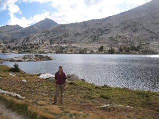
Here I am in front of Marie Lake
JMT hikers can only carry so much food (due to weight and the fact that all food must fit into a bear-proof can), so they mail themselves additional food to certain points along the trail. Here at the Muir Ranch resupply station, buckets of backpackers' leftover food are free for the taking. Powerbars galore!
Notice that all of the buckets in the previous photo are orange or white paint buckets. Now notice one of our own resupply buckets, in a fetching green color representing the fact that it's a pickle bucket, not a paint bucket. Most of our food for the second half of our trip tasted and/or smelled like pickles!
Here we are with newly heavy packs, thanks to our full bear cans
Piute Creek, perfect for an afternoon swim, marks the boundary between the John Muir Wilderness and Kings Canyon National Park
Drat. Now what the heck are we going to do with the knife-juggling, unicycle-riding monkey that we picked up on Day 2?!?