Thursday, February 28, 2008

On the road from Sesriem to Swakopmund, Namibia (February 28, 2009)

Sesriem Canyon, carved by the Tsauchab River
Don't get stranded in Solitaire, Namibia's smallest town!
This is the second time I've crossed the Tropic of Capricorn on this worldwide trip Flamingos wading in the Atlantic Ocean near Swakopmund
Near the coast, the sand dunes are white. The pink color of the dunes at Sossusvlei is due to iron.

More photos of Sesriem and Sossusvlei, Namibia (February 27, 2008)

Dramatic dunes with acacia trees in the foreground
People climbing up the massive dunes (look for the small dots just to the right of the middle of the photo)
"Dead Vlei" - the white area is where water once ran hundreds of years ago, allowing trees to grow. Because the desert is so dry, when the trees eventually died, they simply remained standing. Some of the trees in this photo are between 600 and 900 years old!
A closer view of one of the dead trees
Yet another beautiful African sunset

Sesriem and Sossusvlei, Namibia (February 27, 2008)

Most of Western Namibia is covered by a 32,000 square km sand sea, and the most famous dunes are within the Namib-Naukluft National Park. Sossusvlei is Namibia's number one tourist attraction, and it's easy to see why - the pink dunes (some as high as 200m) are stunningly beautiful set against a brilliant blue sky.

As the sun rose over the dunes, the early morning light turned the sand from a pale yellow-pink color to a bright orange-pink, with stark shadows. Closer to midday, with the sun high overhead, the dunes settled into a uniform soft pink color with only faint shadows.

The desert was equally beautiful at sunset (when the sky turned yellow, orange, pink and purple) and at night (when the sky was filled with the most stars I've ever seen). I even saw a shooting star! In addition to the gorgeous scenery, there was plenty of interesting wildlife - gemboks (also known as oryx), springboks, jackals, geckos and ostriches.
Sunrise at the dunes
Interesting patterns in the sand
Dunes as far as the eye can see, fading from orange to pink
As the sun rose over the dunes, they turned this bright orange color. Note the people at the top of each of the peaks - they'll give a sense of the size of the dunes.
A dead tree at the base of the dunes

Fish River Canyon to Sesriem, Namibia (February 26, 2008)

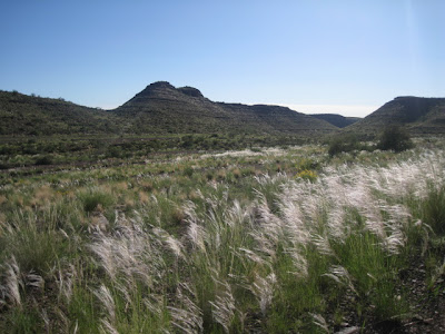
The drive north from Fish River Canyon National Park to Sesriem was long, bumpy and surprisingly beautiful. The region had recently seen a lot of rain, and many of the hills were bright green with new grass. There were also more trees, shrubs and wildflowers than I had expected. The contrast of the greenery, the red soil and the blue sky was quite picturesque.

Long grasses along the side of the road Namibian wildflowers
Blue sky, green hills, red soil An acacia tree with several sociable weaver (bird) nests

Another gorgeous African sunset

Fish River Canyon, Namibia (February 25, 2008)

Fish River Canyon claims to be the second largest canyon in the world, and at 160km long, 27km wide and 550m deep, it certainly looks impressive. The canyon is protected within a namesake national park in the southwestern region of Namibia. The surrounding desert plains are dry and rocky, and are home to some interesting plants and animals. I was thrilled to see a herd of zebras running in the wild, surprisingly camouflaged in their black and white stripes.

The quiver tree (aloe dichotoma), indigenous to South Africa and Namibia
The Fish River Canyon - it's difficult to capture the size of the canyon in a photograph
Another view of the canyon
The canyon rim at sunset
Sunset on the Namibian plains

Western Cape and Orange River, South Africa (February 23-24, 2008)

The landscape along the Western Cape is beautiful and varied. The area is known for its sweeping coastline, its vineyards and its adventure sports. We spent one night at a campsite in the Olifants River Valley, where we sampled the local wines of the Klawer Wynkelder coop winery.

On the second night, we camped at the Orange River, which marks the northwestern border between South Africa and Namibia, and is a popular destination for rafters and campers. From the South African side, one can see the dry Namibian desert in the distance.

Looking down on the Olifants River Valley, with its many vineyards
The road north along the Western Cape...at one point, we saw ostriches running along the highway!
The Orange River at sunset - Namibia is just a short swim away The Orange River area at sunrise

Entering Namibia

More photos of Cape Town, South Africa (February 22-23, 2008)

An old sign on display at the District Six museum in Cape Town. The museum is dedicated to the tens of thousands of residents who were removed from their homes in the Sixth Municipal District of Cape Town when it was declared a whites-only area in the 1960s under the apartheid regime. Laundry drying in a township courtyard
Two boys stand in a shanty town on the outskirts of a township
Makeshift dwellings constructed of everything from corrugated iron to cardboard
Another view of the shanty town beside Cape Town's main highway